
Advance Surveying math
Advance surveying
(CE-105)
Lecturer:
Kamruzzan Asif (B.Sc-AUST
Date: 14 September, 2018
Email:
arifzamance@gmail.com, Cell: 01521218623
Time:
09:00 AM
Photogrammetry: Can be defined as the
a) arts, science & technology
b) to determine the position of physical objects and
environment
c) through the process of recording, measuring and
interpreting
d) of photographic images
Features:
a) Making survey using photographs
b) The science of deducing physical dimensions
c) Making map from a known level
d) A series of techniques for measuring position and
altitude
Field application:
1) Topographical & engineering survey
2) Hilly and mountain region
3) To identifying the form of earth, rock type etc.
4) To high accuracy project
5) Used in rural and urban area
6) Mostly used in planning design
Advantage:
a) Large area covered
b) Less time consuming
c) Inaccessible area can be reached
d) Easily understand, interpret
e) Cheaper (Long run)
Disadvantage:
a) Highly initial cost
b) Costly instrument needed
c) Skill personnel needed
d) Lengthy administrative process
e) Weather dependent
Types:
a) Close range Photogrammetry
d<10 m
b) Terrestrial Photogrammetry
10 m <d<100 m
c) Aerial Photogrammetry
2 km<d<10 km
d) Space Photogrammetry
d>30 km
Why Photogrammetry:
a) Extracting information from map easily
b) Cheaper
c) Extracting qualitative information
d) Highly speed map generation
e) Ideal technology
f) Vast area
g) Irregular shapes of terrain
********************
Exercise:
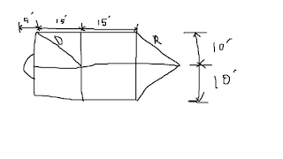 |
|
MACON
|
Find: (i) D=?
(ii) if D=R then find area.
Solⁿ: Area of rectangle
= ab
= (15+15)
x (10+10) sft
= 600 sft
here D=R=√(15)²+√(10)²
= 18.027 ft
Area of triangle= ½ x 2
x 15 x 10
= 150 sft
Area of ½ circle =(π x
5²)/2
= 39.27 sft
So, Total area =
600+150+39.27
= 789.27 sft Ans:
***************


No comments